Where the Site Sits
Prestige Parklane is a residential project inside a working industrial estate laid out by the Karnataka Industrial Areas Development Board (KIADB). The developer calls the address STRR-Devanahalli, after the Satellite Town Ring Road that runs past the estate.
| Registered address | Plot No. 24, Hi-Tech Defence and Aerospace Park Phase-2 (KIADB), Devanahalli, Bengaluru North, Karnataka 562110 |
|---|---|
| PIN code | 562110 |
| Map pin | 13.212962, 77.767110 |
| Taluk and district | Devanahalli taluk, Bengaluru North district (formerly Bengaluru Rural) |
| West side | 45 m-wide Road 5, with the main entry |
| South side | 18 m-wide Road 9 |
| East side | The edge of the KIADB layout |
| North side | Other parts of Plot 24 |
| RERA registration | PRM/KA/RERA/1251/309/PR/150926/008941, approved 15 September 2026 |
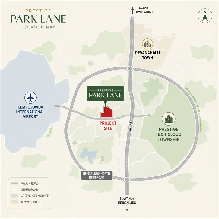
The main entry is on Road 5 and a service entry sits at the south-west corner. Distances on this page are by road from the site's south-west frontage, rounded, unless they are marked as in a straight line.
The 11.76-acre site is only part of Plot 24. The same approved KIADB layout also carries three data-centre buildings, a warehouse, a manufacturing block and a utility block, plus a civic-amenity area. Those blocks are in the approved plan, so treat them as planned neighbours and as part of what some homes will look out on.
Road Connectivity
The Satellite Town Ring Road, numbered NH-648 on this stretch, connects this address, and its section through Devanahalli has been open since 11 March 2024. It passes about 750 m from the site in a straight line, but the nearest place to join it is about 3.3 km by road. From there it leads to Devanahalli and NH-44 in one direction and towards Hoskote in the other. For another address to examine alongside Prestige Parklane, consider Prestige Crystal Lawns, which sets out registered plot options on IVC Road in Singarahalli, Devanahalli.
NH-44 (Ballari Road), the main highway into the city, is reached at Devanahalli, about 9.7 km by road. Central Bengaluru is a long way off: the Hebbal flyover is about 38 km by road and MG Road about 45 km.
| Destination | By road |
|---|---|
| Satellite Town Ring Road (NH-648), nearest place to join it | about 3.3 km |
| Devanahalli town centre | about 9.2 km |
| NH-44 (Ballari Road) at Devanahalli | about 9.7 km |
| Kempegowda International Airport, Terminal 1 | about 19 km |
| Hebbal flyover | about 38 km |
| MG Road | about 45 km |
Airport Connectivity
Kempegowda International Airport is close in a straight line and further by road. Terminal 1 is about 6 km from the site in a straight line but about 19 km by road, and Terminal 2 is about 20 km. The airport has no eastern gate, so the drive goes round the airfield rather than across it: along the ring road to NH-44 at Devanahalli, then south to the airport entrance.
Budget about 26 minutes to Terminal 1 off-peak and about 40 minutes at the morning peak. For a household that flies often that is a manageable airport run, just not the few minutes a straight line suggests.
Metro Connectivity
There is no metro station near Prestige Parklane. The nearest planned station is KIAL Terminals, at the airport, about 18 km from the site by road. It is on the Blue Line Phase 2B from KR Puram, which as at 17 September 2026 is targeted to open in December 2027. No line is planned east towards the site, so a metro trip from here will start with a drive to the airport.
Rail Connectivity
Devanahalli railway station is about 9.6 km by road, on the Bengaluru-Chikkaballapura line, with suburban and passenger services. At that distance it is an occasional option rather than a daily one.
Workplaces Nearby
The strongest thing about this location is the employment on its doorstep, which is industrial rather than office-park work. The Phase-2 occupiers and Brigade's township next door are all within about 3.6 km by road.
| Workplace | By road |
|---|---|
| Brigade's KIADB township (Brigade WTC and Innovation Gardens) | about 1.4 km |
| Exide Energy Solutions lithium-ion cell plant | about 2.5 km |
| Autocrat Engineers | about 2.5 km |
| Carl Zeiss campus | about 2.9 km |
| IFFCO Nano Urea plant | about 3.6 km |
Exide's cell plant covers roughly 80 acres, with a first phase of 6 GWh targeted for the end of 2026 and 12 GWh planned. Brigade's township is a separate development, and nothing in it is shared with Prestige Parklane. The data-centre, warehouse and manufacturing blocks on the same approved layout will add workplaces too, though no employee numbers have been published.
The aerospace SEZ employers (Boeing, Collins, Dynamatic, Rossell and Eaton) are about 12 to 16 km by road on the far side of the airport, with the airfield in between. The nearest aerospace employer, Altius Aerotech, is about 10 km.
| Aerospace workplace | By road |
|---|---|
| Altius Aerotech | about 10 km |
| Eaton Aerospace India | about 12 km |
| KIADB Bengaluru Aerospace Park (core) | about 13 km |
| Collins Aerospace India | about 13 km |
| Dynamatic Technologies | about 15 km |
| Boeing India Engineering & Technology Centre | about 16 km |
| Rossell Techsys | about 16 km |
Schools and Colleges
Chanakya University is close, about 2.8 km by road, but schools are thinner on the ground: a government residential school is about 4.3 km away, and Harrow, Stonehill and Canadian International schools are about 22 to 31 km. For a family with school-age children, the daily school run is the thing to test first.
| School or college | By road |
|---|---|
| Chanakya University | about 2.8 km |
| Kittur Rani Chennamma Residential School (government) | about 4.3 km |
| Brigade Orchards School | about 8.8 km |
| Nalanda Group of Institutions | about 11 km |
| Akash International School | about 11 km |
| Sterling English Residential School | about 16 km |
| Harrow International School | about 22 km |
| Delhi Public School Bangalore North | about 26 km |
| Stonehill International School | about 27 km |
| Ryan International School, Yelahanka | about 30 km |
| Canadian International School | about 31 km |
| Vidyashilp Academy | about 33 km |
Hospitals
Healthcare is a drive. The nearest multispeciality hospital, Ramaiah Leena at Devanahalli, is about 8.2 km by road, and the large private hospitals are in Yelahanka, about 29 to 30 km, and at Hebbal, about 37 km. In a serious emergency that distance matters.
| Hospital | By road |
|---|---|
| Government Hospital, Sulibele | about 7.4 km |
| Ramaiah Leena Multispeciality Hospital, Devanahalli | about 8.2 km |
| Sri Shirdi Sai Hospital, Devanahalli | about 8.9 km |
| Manasa Hospital, Devanahalli | about 9.5 km |
| Akash Institute of Medical Sciences | about 11 km |
| Government Hospital, Devanahalli | about 11 km |
| Cytecare Cancer Hospitals, Yelahanka | about 29 km |
| Manipal Hospital, Yelahanka | about 30 km |
| Sparsh Hospital, Yelahanka | about 30 km |
| Baptist Hospital, Hebbal | about 37 km |
| Aster CMI Hospital, Hebbal | about 37 km |
Retail and Hospitality
Nothing for the weekly shop is within about 7 km: the nearest supermarket-grade retail is at Brigade Orchards, about 7.1 km by road, and the first full mall about 27 km. Hotels are better served, because the airport draws them.
| Destination | By road |
|---|---|
| The Arcade and Bazaaro, Brigade Orchards | about 7.1 km |
| Devanahalli town centre | about 9.2 km |
| DMart, Devanahalli | about 10 km |
| DoubleTree by Hilton Bengaluru Airport | about 13 km |
| Taj Bangalore at the airport | about 20 km |
| Orion Uptown Mall | about 27 km |
| Bhartiya Mall of Bengaluru | about 30 km |
| Phoenix Mall of Asia, Hebbal | about 35 km |
The Trade-offs, Honestly
Devanahalli has no Cauvery supply - what the taluk actually runs on.
Water is the first question
Devanahalli has no Cauvery supply. The taluk runs on borewells and tankers and is classed as over-exploited for groundwater, with extraction reported at around 169% of the permissible level. The registered water source for Prestige Parklane is borewell, and the project registers rainwater harvesting, groundwater recharge and a sewage treatment plant. Cauvery Stage VI, a ₹6,939 crore scheme to bring 500 MLD to Devanahalli, Hoskote and Anekal, was approved in February 2026, but the earliest supply date discussed is around 2028.
Aircraft on approach
The site lies about 4.7 km beyond the eastern end of the airport's northern runway, within about 700 m of its extended centreline. Aircraft on a standard 3-degree approach to that runway pass over at about 250 m, roughly 800 ft, and how often depends on the direction the airport is operating in. Stand on the site during a busy arrival period and judge it for yourself.
Daily needs are all a drive
Nothing a household uses every week is within about 7 km: supermarket-grade retail is about 7.1 km away, the nearest multispeciality hospital about 8.2 km and the first full mall about 27 km. That may improve as the area fills in, but plan around today's position.
Not a city-commuter address
ITPL Whitefield is about 35 km by road, Manyata Tech Park about 37 km and MG Road about 45 km, so a daily commute into the city's established office clusters would be long in both directions. It suits people employed in the airport belt instead.
An industrial estate still being built out
Prestige Parklane sits inside a KIADB industrial estate, not a residential suburb. The approved layout it is part of also carries data-centre buildings, a warehouse, a manufacturing block and a utility block; Exide's cell plant, the Carl Zeiss campus and IFFCO's plant are within about 3.6 km; and the estate's roads and plots are still filling in. Expect construction traffic, industrial neighbours and an outlook that depends on which way your tower faces.
Who This Location Suits
It suits a household whose work is in the airport belt, at the Phase-2 employers, in Brigade's township next door as it is built, or at the airport itself, and people who fly often. It suits buyers who would rather live beside an open ring road and a growing employment cluster than in an established suburb. Anyone planning to let a smaller home to people who work in the estate should test that demand locally first.
It suits less well a household commuting daily to Whitefield, Manyata Tech Park or central Bengaluru; a family that wants an international school or a large private hospital close by; anyone who would find aircraft on approach hard to live with; and anyone who needs to move in before the proposed completion date of 31 December 2030.
What to Verify Before You Commit
- Visit on a weekday at the morning peak, and again during a busy arrival period, long enough to see and hear the approach traffic.
- Drive your own weekly routes, to work, school, a hospital and the airport, at the times you would travel, and walk the approach from the ring road to the gate.
- Ask the developer in writing about the water source for the finished project, the storage planned and the tanker contingency.
- Ask which of the data-centre, warehouse, manufacturing and utility blocks your tower faces, and how close they are. The master plan shows where each tower sits.
- Check the registration at rera.karnataka.gov.in under PRM/KA/RERA/1251/309/PR/150926/008941, and confirm that your agreement carries the registered address with PIN 562110.
Prestige Parklane FAQs
Is Prestige Parklane on the Satellite Town Ring Road?
Close to it. The Satellite Town Ring Road (NH-648) passes about 750 metres from the site in a straight line, and the nearest place to join it is about 3.3 km away by road. The developer brands the location "STRR-Devanahalli".
Is there a metro station near Prestige Parklane?
No. The nearest planned station is KIAL Terminals on the Blue Line Phase 2B from KR Puram to the airport, about 18 km away by road and targeted for December 2027. No line is planned towards the site.
What is near Prestige Parklane?
The industrial occupiers of the aerospace park's Phase-2: Exide's lithium-ion cell plant about 2.5 km away, Autocrat Engineers about 2.5 km, Chanakya University about 2.8 km, Carl Zeiss about 2.9 km and IFFCO's Nano Urea plant about 3.6 km. Brigade's KIADB township is about 1.4 km away. Devanahalli town is about 9.2 km and Devanahalli railway station about 9.6 km.
What will be next to Prestige Parklane?
Prestige Parklane is part of a larger KIADB plot whose approved layout also carries three data-centre buildings, a warehouse, a manufacturing block and a utility block. Ask which of them your tower will face.
Will aircraft noise affect Prestige Parklane?
The site lies about 4.7 km beyond the eastern end of the airport's northern runway, within about 700 metres of its extended centreline, so aircraft approaching from the east pass close by at roughly 250 metres. Visit during a busy arrival period before deciding.